 Homepage Homepage |
www.aberffraw.wales | 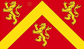 |

Aberffraw (pronounced Aberffro) population 620, is a small coastal village at the mouth (Aber) of the river (Afon) Ffraw on the west coast of Anglesey 14 miles (21 mins) from the Brittania Bridge. It has a long sandy beach and estuary and expansive sand dunes to the south-west which are of Special Scientific Interest (SSI). With its tidal estuary, wildlife, numerous traditional white Welsh cottages, church, village pub, village hall, art gallery, shop, post-office and tea rooms and superb views of the Welsh mountains it is a popular summer stop off just south of the busy holiday resort of Rhosneigr and gourmet eating of the Oystercatcher.
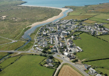
Copyright www.pixaerial.com
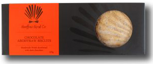 Aberffraw Biscuit Company
Aberffraw harbour once important for large sailing vessels and fishing is now mostly silted up (since the great storm of 1331) leaving this lazy village just off the beaten track of the main UK Holyhead road and rail routes to Ireland and it is more famous for its biscuits (oldest in Britain) than anything else. In 1949 it was one of the poorest villages in Wales still without access to running water and electricity.
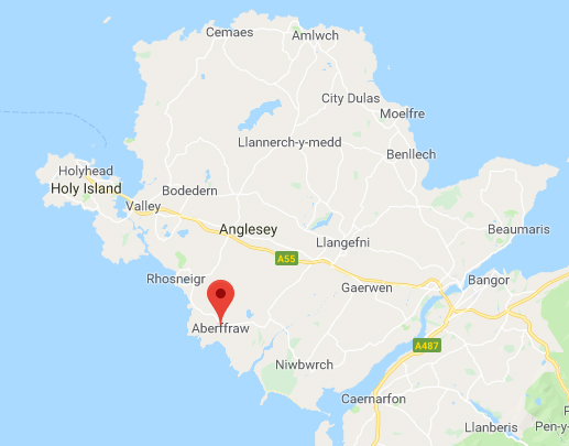
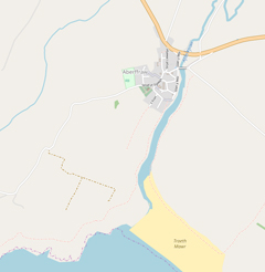
From Google Maps
Postcode - LL63 5LQ
Road - A4080
Rail - Bodorgan
From OpenStreetMaps
Contributers
The House of Aberffraw ruled for 8 centuries, through Rhodri the Great (870ad), housing the Welsh Laws (900AD), and surviving attacks by the Vikings, Irish and Normans. In the 12th century Aberffraw became one of the 3 chief thrones of Britain and under Llywelyn the Great the capital of Wales.
Eventually succumbing to England's Edward 1 in 1282 the lands were passed to the Bodorgans/ Meyricks and Bodowens/Owens and materials were used to build Beaumaris Castle.
Aberffraw is also the birthplace of the father of the Scottish King Richard II and the House of Stuart. More recently a nearby home for the current Prince William and Kate until the birth of George, another possible future King of Britain.
In Welsh mythology Branwen and Matholwch married at Aberffraw.
St Beuno's 12th century church stands at the top of the village and two miles east is the 6th/12th century St Cadwaladr and a mile west the medieval church of St Cwyfan or Church in the Sea.
Aberffraw was a busy port for exporting Anglesey produce and home to great fishing vessels. However, following the Great Storm of 1331 the harbour began silting up and sand dunes formed diminishing the importance of Aberffraw, compounded by its land transport isolation. After being declared the poorest village in Anglesey in the 1940s, in the 1950s & 1960s many of its traditional small white Welsh cottages fell into disrepair and were demolished, being replaced by council housing and the addition of a small housing estate unknowingly built over the historic Princes Palace area. A few traditional cottages and houses were saved by the Conservation area program of the 1980s just maintaining the village's character. It also now has an active Village Hall (since the 1950s), Art Gallery, pub, cafe, village shop and post office.
In recent times many properties have become holiday cottages or purchased by outsiders from other parts of Wales or North West England keeping the tourism industry and local trade alive but unfortunately diminishing the Welsh language previously prevalent in the village.
Other key dates:-
- 1729 Eglwys y Beili ruin turned into a school by Sir Arthur Owen
- 1731 A stone bridge built over the river (current horsepack bridge)
- 1816 About 43 properties recorded
- 1843 post Office opened
- 1871 Village well erected
- 1871 First trans-Atlantic telegraph cable at nearby Cable Bay
- 1893 Around 85 houses recorde
- 1932 New road bridge built
- 1949 recorded as poorest village in Anglesey
- 1949 Electricity introduced
- 1952 Mains water introduced
- 1958 Village Hall opened
- 1960s Allotments developed as housing & Maes Llewelyn estate built over original palace
- 1960s Kyffin Williams, artist, produces paintings of Church and Cottages
- 1970s Conservation Area introduced
- 1980s Holiday village prospers
- 2000s
Aberffraw Biscuits reintroduced oldest biscuit in
Britain; Llys Lewellyn Cafe & Shop
- 2010s Internet, Trac Mon, celebration of Village Hall 60th birthday, Crown Pub reopens
- St Beuno's Church, 12c double knaved church grade II* listed
- Seion Methodist Chapel, grade II listed
- Pendref single storey vernacular cottage, early 18c, grade II listed
- Willington House, schoolmasters house
- Eagles cottage 1729 former charity school, grade II listed
- Numbers 25-37 Bodorgan Square historic village centre, 18-19th C
- Aberffraw Post Office & Shop - Post Office with cash and lottery machines, also sells a small selection of everyday foods, milk, bread, eggs and bacon and Aberffraw biscuits. See also the postmaster’s photographic mugs, cards, keyrings, calendars etc.Open Monday-Saturday 9-5.30 and Sunday morning.
- Aberffraw Village Pub – The Crown (Y Goron). Friendly local pub with bar, sports TV area, restaurant and seated garden. Try the guest cask ales from local micro-breweries and the famous Steak and Ale pie. Open all week, restricted opening and food in winter. Dog friendly. Meal Booking 01407 840222
- Heritage
Centre/Café Llys Llewelyn - at the entrance to
the village. Heritage centre gift shop, bike hire,
toilets,
(the latter three currently defunct 2017-2019), indoor
and outdoor tearooms. Excellent cakes. Also you can
order in advance takeaway cakes and meals. Open
Mon-Fri 10-3.30pm. (Closed down 2019)
- Aberffraw Village Hall - near the top of the village. Provides for community and club events including Bingo, Yoga, Line Dancing, Games, Bowls, Dog training, music, table top sales and the annual Village Horticultural and Craft Show.
- Old School Gallery - next to St Beuno's Church. Houses exhibitions of art, photography and craft as well as facilities particularly suited to autistic artists.
- Min y Mor Community Room - provides a meeting place for local residents and aftrenoon events such as Knitting and Nattering, Weekly Quiz, and the Day Club.
- St
Beuno's Church - services in Welsh and English and
don't miss special events such as
Harvest, Rememberance Sunday,
and the Carol Service.
Shops Outside Aberffraw
In addition to the local Post Office Convenience Shop in Aberffraw which is open all week (see above) try :-
- Bethel (3 miles: right from Aberffraw along A4080, take 1st left and follow signs to Bethel) - Convenience Store including fresh baked goods, sausage and bacon.
- Rhosneigr (5 miles) Spar, FatFace, Chippy, Mojos Creperie
- Llangefni (9 miles) ASDA, Iceland, Lidl, Butchers, Banks
- Menai Bridge (15 miles) Waitrose
- Holyhead (15 miles) Tesco, Morrisons, ASDA
- Llanfairpwllgwyngyll (14 miles) Cooperative
- Valley (11 miles) or Gaerwen (10 miles on A5) Stermat – sells absolutely everything except food!
Transport
- Bus (No. 25)- From Bodorgan Square Aberffraw to Holyhead (45 mins) via Rhosneigr, Llanfaelog, Engedi, Valley, Penhros, Tescos. Monday – Saturday 2 hourly 8am-4pm.
- Trains – Bodorgan or Ty Croes Station to Holyhead or Bangor – Chester-Crewe etc.
- Leaving Anglesey
- Brittannia Bridge (14 miles, 21 mins)
- Menai
Bridge (15 miles, 24 mins)
- South
from Church / Village Hall down to harbour and across
stone bridge and along south bank of estuary to beach,
stunning views, along beach and back through or along
south edge of sand dunes to stone bridge. Highlights,
high tide, sunrise over Snowdonia, colourful Aberffraw
estuary cottages, stunning views where Sahara meets
sea and mountains of Llyn Peninsula.
- East
across main road, cross river and along road or sand
dunes to Llyn (lake) Coron, back around lake and sand
dunes or via Bodorgan Station and Llangadwaladr, then
main road (A4080) or Aberffraw dunes. The longer route
via Bodorgan station is more suitable for wet weather
or as a short cycle route. Highlights, wildlife around
the lake and the old station.
- North along coastal path on North side of estuary around standing stones at headland and along coastal path through to the Church in the Sea. Back via road (Church Street) to Pendref /Village Hall or via track along Anglesey Motor Racing Circuit then path along fields to half way point of Church Street. Highlights, stunning sunsets over headland and Church in sea.
- Trecastel / Cable Bay (2 miles, 5 mins) – car park, ice cream van – sand, sea and surf or walk around coastal path 30 mins via Mesolithic burial chamber to Porth Nobla’s sandy/rocky bay and back via road
- Porth Nobla (2.3 miles, 5.5 mins) – layby with path down to tremendous beach, rocks, dunes, waves and views across to Rhosneigr. You can walk along the beach or dunes into the resort for refreshments, well worth the hour each way. Slightly shorter if you choose the Oystercatcher restaurant/Will’s bar instead!
- Tywyn Fferam (2.5 miles, 6 mins) – car park with toilets. Just a few hundred yards beyond previous walk, same applies but slightly shorter.
- Rhosneigr (5 miles, 11 mins) – turn left at clock tower down high street and park in library car park. Walk in either direction along beach and dunes or drop into
- Mojos on High Street for a very French galette or crepe.
- Rhoscolyn (15 miles, 27 mins via A55 and Valley and Four Mile Bridge) – park at White Eagle (excellent food) or Rhoscolyn Beach and take a circular coastal walk via the archway stacks in the sea cliffs with views towards Trearddur Bay and South Stack and back across fields to the pub.
- Trearddur Bay (16 miles, 24 mins as above) – enjoy the bay, ice cream vans, beach bar and restaurant, Sea Shanty or Trearddur Bay Hotel. Walk south along the coastal path to the archway stacks and back. Stunning cliff views.
- South Stack (18 miles, 30 mins as above) – park for free and make use of this stunning RSPB reserve with its Peregrines, Choughs and Ravens. Clamber up the rocks or down the steps to the lighthouse made famous by the front cover of Roxy Music’s Siren LP. Bring the binoculars. Café/restaurant and shop.
- Holyhead (15 miles, 21 mins via A55) – either wander around the old town or harbour and see the big ships crossing to Ireland, visit the art gallery (Ucheldre), or catch up on shopping at the giant Tescos, Asda, Morrisons, Argos, or Wilkos just off A55 junction 2.
South & East
- Maltraeth (4 miles, 9 mins via A4080) walk along harbour wall with views over the estuary and waterlife. Recommend Riverside Café & Gallery.
- Newborough (8 miles, 23 mins) – park in Newborough Forest (£) toilets, food van. Stunning walks through forest or along vast stretches of sandy beaches. At low tide visit Llanddwyn Island. Marram Grass restaurant nearby
- Plas Newydd (15 miles, 26 mins) National Trust stately home and gardens. Check opening times.
- Llanfairpwllgwyngyll (14 miles, 22 mins on A5) – parking, pubs, toilets, arts, crafts, galleries, clothing, gifts and of course the famous Llanfairpwllgwyngyllgogerychwyrndrobwllllantysiliogogogoch railway station.
- Menai Bridge (15 miles, 25 mins) - interesting town and quaint harbour with views of the Menai straits and old bridge. Many craft shops and pubs and Dylans restaurant.
- Beaumaris (20 miles, 33 mins) – beautiful harbour town with interesting castle, pier, shops, galleries and many eating places as well as views over Snowdonia.
- Also well worth driving further East to Penmon to see the Priory, Lighthouse and Puffin Island with views across to Llandudno. Car park near lighthouse with food and toilets.
East & North
- Llangefni (9 miles, 17 mins) – picturesque town, administrative centre of Anglesey. Markets, countryside park railway walk, Oriel Ynys Mon gallery, Shops, eating.
- Moelfre (17 miles, 33 mins) – park near the quaint harbour and walk along the coast. Remember to visit Ann’s Pantry. Some stunning long sandy beaches just north of here too such as Lligwy Beach.
- Church Bay (19 miles, 34 mins) – small harbour and sandy beach, car parks, excellent Café shop and outstanding coastal walks especially the cliff top ones running north. Also the renowned Lobster Pot restaurant and nearby pub at the top of the hill.
- Cemaes
(22 miles, 37 mins) – visit the interesting harbour
with pubs, walks and views and ‘Stone Science’
information guides or pop along to the barren stony Cemlyn
Bay fronting a natural bird breeding area. Bring the
binoculars. Also don't miss Llanbadrig's
church on a sea cliff.
- Amlwch (19 miles, 34 mins) – old port housing the Amlwch Industrial Heritage Trust.
- Red Wharf Bay (17 miles, 35 mins) – park by the old Ship Inn (excellent food and drink), half way around near Pentreath or at the other end below LLanddona. Miles of sand and sea and views and flat to walk along.
- HISTORY
- Wikipedia factual overview
- Roman Fort
- Archaeology
- Genuki
historic records, Gazetteer
1868 & Lewis 1833
- House
ofAberffraw Wikipedia
- Anglesey
Records Census, Baptisms, marraiges, Burials
- Red Dragon Welsh Early History
- Anglesey
Gazetteer 1807 1808 1840 1850 1870
- Frith Old photos & Maps
- Aberffraw
Castle history
- Aberffraw Castle Youtube video
- Llys & Motte Aberffraw castle data
- Llys Site
- Llys
& Maerdref Old Courts of Gwynedd
- Conservation Area superb 89 page document
- Conservation Llewelyn Street document
- Aberffraw
Manor National Archives 1293-1966
- Aberffraw Eisteddford 1847
- Aberffraw Biscuit History
- Eagles
Cottage & School 1829-
- Coastal
Paths Aberffraw to Rhosneigr
- JNNC dunes nature report
- Aberffraw School a great archival site
- Aberffraw
School National admission records 1870-1913
- Listed Buildings in Aberffraw
- Gas Pipeline Survey detailed pictorial report
- Aberffraw Watermill
- St Beuno's Church Aberffraw
- St
Beuno's Church Inside views
- St Cwyfan / Church in the Sea
Last
Updated 11 September 2020, MM